|
Miscellaneous Sites
Associated with the Third Reich
Part 2
The following sites can be found
on this page. Click these links to proceed directly to a particular site.
Bavaria-Thuringia border (Luftwaffe radar site), Doggerwerk
underground factory site (Bavaria), Nürnberg Deutsche
Stadion model site (Bavaria), Bayreuth (Bavaria), 11th Armored Division in northern
Bavaria (and two 1945 scenes in southern Bavaria), Kampfgruppe Peiper tanks in Tondorf
(Nordrhein-Westfalen), Autobahn
ruins (Bavaria), Autobahn monument at Hirschberg
(Thuringia), Autobahn bridge at Jena (Thuringia),
Autobahn service station at Michendorf
(Brandenburg-Berlin), Autobahn bridge at Kaiserslautern
(Rheinland-Pfalz), Autobahn Rasthof at Hermsdorf
(Thüringen).
-
|

|

|
| These
are the remains of a Luftwaffe radar site on the border between Bavaria
and Thuringia, north of Bad Königshafen in northern Bavaria. This site,
built in late 1944 and code-named "Made," housed a "Würzburg-Riese" radar dish and
a "Jagdschloß" radar array, along with associated
administration and supply bunkers. Above - ruins of the bunker for the
"Jagdschloß" radar. Below - left, ruins of the supply bunker;
right, mounting base for the "Würzburg-Riese" radar
dish. The period photo just below shows a "Würzburg-Riese" radar dish
mounted on its base. (Click here
to see another such radar site near Schweinfurt.) (Bundesarchiv Koblenz) (MapQuest
Map Link) |
|

|

|

Doggerwerk Tunnel System
|

|

|
| As the
German military industries moved underground in 1944, a site was planned
for assembly of BMW 801 aircraft engines. This was first known as
Project "Esche 1," then later as "Dogger." A series
of tunnels was dug into the Houbirg hill overlooking Happurg, east of
Nürnberg. The planned completed size was some 120,000 square meters,
but only about 15% of the tunnels were completed, and production never
started. The tunnels were the standard for late-war underground
construction, being arches lined with concrete. The tunnel entrances
were bricked up or shut with concrete and covered over by the U.S. Army
after the war. Most of the entrances are still covered with earth today
- the one on the left of the lower group in the plan (seen here on the
right) is partially exposed today (this is Tunnel G). |
|

|

|
| Tunnel F
(next to the right in the plan) has been re-opened, but is kept locked.
The photo on the right shows a view of the tunnel interior, taken
through the bars of the (locked) gate. |
|

|

|
|
This is the entrance to Tunnel
E, covered with earth. |
Higher on the hill above the
tunnel entrances was a concrete water reservoir (one source says this
ruin was actually a workshop building at the top of a cable lift
system). |
|

|

|
| The site
is now a memorial to the victims from the concentration camp at Flossenbürg,
encamped nearby at Hersbruck, who died building these tunnels. On the
right is a period relic found at the site - a piece of rail from the
narrow gauge railway that ran to the tunnel entrances. (MapQuest
Map Link) |
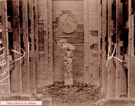
Deutsche
Stadion Model Site
|
|

|
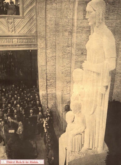
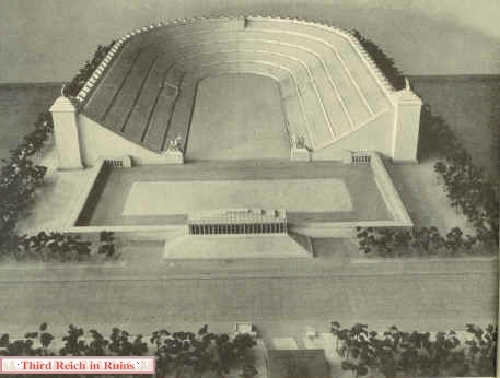
| Architect
Albert Speer designed the Deutsche Stadion,
or Great German Stadium in Nürnberg to be the largest sports arena in
the world, with seating for 405,000. The stadium (seen as an
architectural model on the left) was never built, but a full-scale model
of part of the seating area was built, in order to test the view from
the upper levels. This model was constructed of wood with concrete
foundations on a hillside in the Hirschbach valley, near the village of
Oberklausen, east of Nürnberg. On the right, Speer inspects the model
along with other dignitaries. The small dark rectangle seen at the top
of the seating area was a block of 60 workers, testing the view. And let
me assure you - the ground looks every bit as far away from up there
today, as those workers looked from down below! (left - "Die
Stadt der Recihsparteitage - Nürnberg und die M.A.N."; right - from "Illustrierter Beobachter," 17 March
1938) |
|

|

|
| Speer's
Stadion would have dwarfed the other structures at the Nürnberg
Party Rally Grounds, including the Kongreßhalle, seen at the upper
left of the model on the left. On the right is an artist's conception of
the Stadion from ground level - the tiny people at the bottom are to
scale! (from "Kunst in Deutschen Reich") |
|

|

|
|
Another view of the
architectural model on the left, with an overall view of the full-scale
model site on the right, during initial construction. (left - period postcard) |

Hitler (center) visits the site with
Albert Speer and others on 21 March 1938. (Bundesarchiv)
|

|

|
| A closer view of the model site, with the corresponding view today. The
trees to the right of the rock mask the series of concrete foundations going up the
hillside (the lowest one is visible as a dark strip near the bottom,
above the road),
but the concrete bases for the separate tower can be seen near the top
on the right. Apparently, the model tested two different angles for the
seating arrangements, as seen on the left. The angles of the hillside
for these two sections are still different today. |
|

|

|
| The
wooden parts of the structure were removed by the U.S. Army after the war,
but the concrete bases are left today. On the
left, one of the massive concrete walls that supported the cross levels
of the wooden seating area model. On the right, some of the many smaller
blocks that supported the seats themselves. (The wood was used to
rebuild a local village, which had been largely destroyed during a
defense by SS troops during the U.S. Army advance in April 1945.) |
|

|

|
| On the
left, the supports for the model of the upper rim of the stadium, above the seating area - seen at the upper left of the full-scale
hillside model photo. On the right, concrete supports for the separate
tower model, on the opposite side of the hill face. (MapQuest
Map Link) |
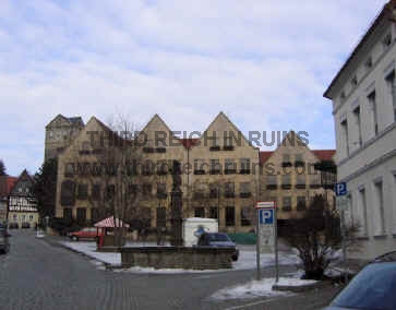
Bayreuth
|

|

|
| The Haus
der Deutschen Erziehung (House of German Education) was located on
Luitpoldplatz (this part is now called La Spezia Platz) in the northern
part of the downtown area. The building was substantially damaged by
bombing during World War II, and was rebuilt in 1947. Subsequent
renovations have changed its appearance considerably. Today the building
is used by the E.ON energy corporation. (period postcard)
(MapQuest
Map Link) |
|

|

|
| The long
building to the left was known as the Steno Haus, but it has been
replaced by modern construction. (period postcard) |
|

|

|
| Dedication
of the House of German Education on 12 July 1936. (left - from "Illustrierter Beobachter,"
23 July 1936; right - from Fr. Prof. Gerdy Troost, "Das Bauen im neuen Reich," Bayreuth, 1938) |
|

|

|
| This
market hall was built in Bayreuth in 1935. The fresco on the front wall
was painted by Oskar Martin-Amorbach, a respected artist whose works
were displayed in the Haus der Deutschen Kunst.
Now called the Rotmainhalle (after the "Red" branch of the
Main River), the building is almost surrounded by the modern Rotmain
Center. |
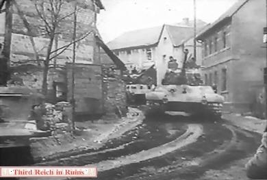
11th Armored
Division in Northern Bavaria, April 1945
|

|

|
| At
the end of the war the U.S. 11th Armored Division moved through
northeastern Bavaria, from Coburg to Kronach,
Kulmbach, and Bayreuth,
then from there to the southeast through the Bavarian Forest, and into
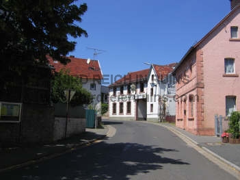
Austria. This M4A3 Sherman tank passed through the village of
Marktzeuln, southwest of Kronach, on 12 April 1945. The view is almost
exactly the same today. (National
Archives, RG 111-SC) (MapQuest
Map Link) |
|

|

|
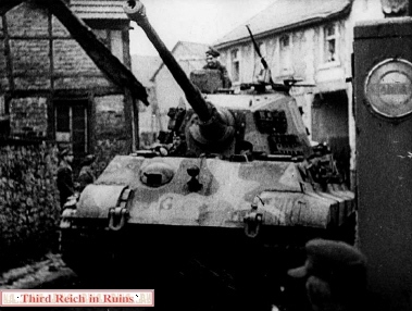
| This M4A3 Sherman tank
is advancing into the center of Kronach, which burns from the fighting,
on 12 April 1945. The Fachwerk building in the center background
was not rebuilt in its original style. (Many thanks to Louis Lanier Hurdle, who identified
this location (which had eluded me) and sent the modern photo.)
(U.S. National Archives, RG111-SC) (MapQuest
Map Link) |
|
|
|
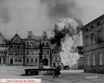
| GIs
of the 101st Infantry Regiment move into the upper town area of Kronach,
near the castle, as an ammunition trailer explodes in the background.
All of the buildings in the center background were later replaced by more
modern construction. (Many thanks to Louis Lanier Hurdle, who identified
this location and sent the modern photo.) (National
Archives, RG 111-SC-206235) (MapQuest
Map Link) |
|

|

|
| This
M4A3 Sherman tank was photographed while driving on the Autobahn (now
A9) north of Bayreuth, toward Berlin, on 19 April 1945. This was
the interchange for the secondary road leading to Marktschorgast and
Gefrees (now Exit 37 for Gefrees). (National Archives, RG
111-SC) (MapQuest
Map Link) |
|

|

|
| The
11th Armored Division eventually moved southeast from Bayreuth, ending
the war near Linz in Austria. This M4A3E8
Sherman tank is moving through the town of Gallneukirchen, northeast of
Linz, on 4 May 1945. The large building in the period photo is now gone,
but the building seen behind the tank appears in the left-center of the
modern photo (which was taken on 5 May 2005). (National Archives, RG
111-SC) (MapQuest
Map Link) |
|

|

|
| This
is not the 11th Armored Division nor
northern Bavaria, but an M4A3 Sherman tank of an armored unit advancing
toward Berchtesgaden in early May 1945. The tank had come from Munich
(north) and was passing through the town of Miesbach, where it turned
east toward Rosenheim and Berchtesgaden. A column of German POWs
(including some mounted on horses) can be seen marching toward
Munich. ("The
Epic of the
101st Airborne," 101st Airborne Division Public Relations Office, Auxerre, France,
1945) (MapQuest
Map Link) |
-
|

|

|
| Again,
not the 11th Armored Division nor
northern Bavaria. This is Troop B of the 116th Cavalry Reconnaissance
Squadron, 12th Armored Division, in Murnau am Staffelsee in southern
Bavaria. According to the combat photographer's caption, as the U.S.
unit arrived in Murnau on 29 April 1945 to liberate Polish prisoners at
the military barracks, SS staff cars drove up and two SS soldiers were
killed during the resulting gun battle. The barracks is now the
Bundeswehr Werdenfelser Kaserne. (U.S. National Archives, RG
111-SC-205617) (Google
Maps link) |
 |
Tiger Tanks
of Kampfgruppe Peiper in Tondorf
Remains
of Autobahn "Section 46"
|

|

|
| Hitler's
planned Autobahn highway system called for three main north-south
highways, linked by several east-west connectors. Some of the
construction projects were halted by the start of war in 1939 - one of
these was the north-south section between Fulda and Würzburg,
known as "Strecke 46" (Section or Stretch 46). Several bridges
had been built, and parts of the highway were ready for surfacing. However, the
eventual completed north-south highway in this area, today's Autobahn
A7, was built about 20 kilometers east of the planned route of Strecke
46. So the remains of Strecke 46 can now be found along its original
route. See the Strecke 46 homepage (in German) - Strecke46.de
(info on guided tours also on this page).
The relic seen above was a bridge abutment for a bridge across
the valley of the Fränkische Saale river, at Schonderfeld west of Hammelburg.
The artifact is used today by climbing clubs, who put the cross and
railings on the top. (MapQuest Map
Link)
|
|

|

|

|
| This
bridge over a small road near Burgsinn, north of Gemünden,
is in surprisingly good condition today. Just passing under the bridge,
one would not realize there is actually no roadway up above. This road
was part of the route of Task
Force Baum, whose tanks passed directly under this bridge and went
on up the hill, toward Gräfendorf and Hammelburg.
(MapQuest
Map Link) |
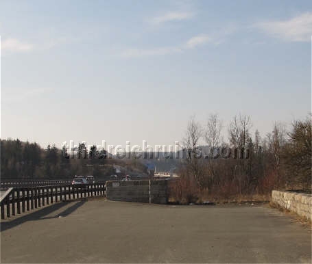
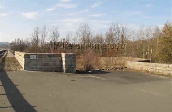
Autobahn
Border Monument near Hirschberg

A view from the other end of the bridge.
A somewhat similar pull-off was located on this end. (Bundesarchiv)
|

|

|
| The
bridge over the River Saale still shows the classic design of many Third
Reich period bridges. (from Fr. Prof. Gerdy Troost, "Das Bauen im neuen Reich," Bayreuth,
1942) |
|

|
The Hirschberg Saale
Bridge site was featured in Nazi propaganda posters advertising the
German Autobahn highway system.
This aerial view
shows the entire site as well as the bridge, which was similar to the Holledau
Bridge. This scene would look radically different today due to the
large amount of traffic that now travels the German Autobahns.
|
Autobahn
Bridge at Jena
|

|

|
| One of
the longest bridges in the Autobahn system was that crossing the valley
of the Saale River south of Jena (on the current Autobahn A4). The view
on the left above shows an architectural model of the bridge. On the
right, a GI inspects a destroyed span that was blown by retreating
German forces in April 1945. (right - National Archives, RG
111-SC-324085) (MapQuest
Map Link) |
|

|

|
| The Jena
Brücke as seen in 1938, with a corresponding view today. ("Das
Bauen im neuen Reich" by Fr. Prof. Gerdy Troost, Bayreuth, 1938) |
Autobahn
Service Station at Michendorf (Berlin)
|

|
One
of the few remaining original buildings that was once a service station
for the Autobahn system can be seen on the southwest side of Berlin, at
Michendorf.
The building is located on the eastbound side of Autobahn A10 (south
side). The building is no
longer a service station, but is part of the Michendorf Raststätte
(rest area and restaurant).
(MapQuest Map
Link) |
Autobahn
Bridge at Kaiserslautern
|

|

|
| The
Waschmühltal Bridge for Autobahn A6 at Kaiserslautern was built to a
design by Fritz Todt and Paul Bonatz. (1. Deutsche Architektur
und Kunstahndwerk Ausstellungskatalog, 1938) (Google
Maps link) |
 |
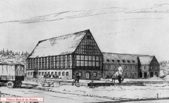
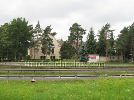
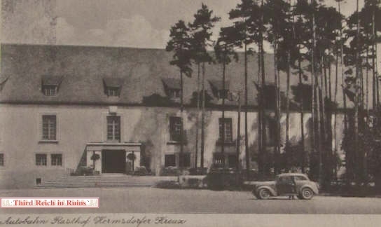
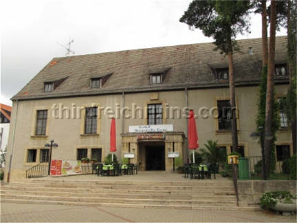
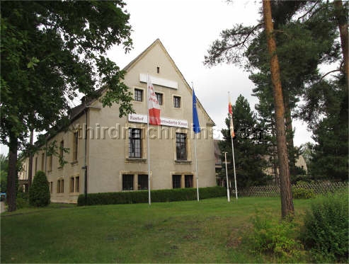
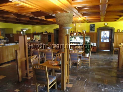
Autobahn
Rasthof at Hermsdorf
 Go to Miscellaneous
Sites, Part 3
Go to Miscellaneous
Sites, Part 3
Go to the War Memorials page
Back to the Third Reich in Ruins homepage
|