Geoff Walden


Home ] Up ] Miscellaneous Sites Part 2 ] Miscellaneous Sites Part 3 ] Misc. Sites Part 4 ] Miscellaneous Sites 5 ] Misc Sites Pt. 6 ] [ Misc Sites 7 ] Miscellaneous Sites Pt. 8 ] Misc. Sites Pt. 9 ]


Miscellaneous Sites

Associated with the Third Reich

Part 7


   The following sites can be found on this page: Wusterhausen an der Dosse (Brandenburg), Lienz (Tyrol, Austria), Kulmbach (Bavaria), Geretsried (Bavaria), Deiningen Muna (Bavaria), Heuberg Airfield (Bavaria), Carinhall (Brandenburg), Ravensbrück (Brandenburg), sites in Mittelfranken - Dinkelsbühl, Rothenburg ob der Tauber, Ansbach and Lichtenau (Bavaria); Neumarkt in der Oberpfalz (Bavaria); Adolf Hitler Koog (Schleswig-Holstein); Masurian Canal Locks, Poland.


Adolf Hitler Platz (town square) of Wusterhausen an der Dosse, from a 1930s postcard. Note the large swastika on the front of the Rathaus (town hall).


Hotel Post in Lienz, Tyrol, Austria, from a 1942-dated postcard. Note the Norwegian, Nazi, Austrian, French, and Swiss flags hanging from the hotel. The buildings remain hardly changed today, but the hotel is now the Altstadthotel Eck.

-

This 1935 postcard depicted sites in Kulmbach in northern Bavaria. The view is a collage type, as the Plassenburg fortress on the hill is not visible from the Marktplatz with the old City Hall (Rathaus) in view like this.  (period postcard courtesy James Lees)  (Google Maps link)


Geretsried

A large factory area for the manufacture of explosives and munitions was established along the Isar River at Geretsried, south of Munich, in 1938-41. This was actually two separate projects, codenamed "Tal I" and "Tal II," the northern part ("Tal I") used for the manufacture of high explosives and fuses, while the southern part ("Tal II") was used mainly for munitions assembly and storage. After the war most of the factory buildings and bunkers were destroyed, but some of the buildings are in use today for other purposes, and several bunker ruins remain. Shown above are the ruins of Bunker 356, for the manufacture of picric acid, a high explosive filler for artillery shells. This bunker ruin is commonly known today as the "Blauer Bunker" due to the predominant color of its graffiti. (Period references sometimes refer to this explosives factory area as Wolfratshausen, because it was built in the Wolfratshausen forest, but the area is today part of Geretsried.)  (Google Maps Link)

The bunker ruin shown below is on the far northern part of "Tal I." The objects on the right are "petrified" bags of cement - bags of cement mix that were abandoned outside the bunker entrance in 1945, and subsequently hardened from rain water (a not unusual sight at several Third Reich tunnel projects that were unfinished when the war ended).
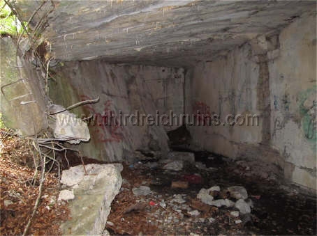
 

The southern area, "Tal II," had a bunker area for the storage of the munitions that were manufactured nearby - a Muna - Munitionsanstalt. Like "Tal I," it was largely destroyed after the war, but many bunker ruins remain. Representative of these is Bunker 4, seen here. (Check the Contents Page for links to other Munas found on the "Third Reich in Ruins" page.)  (Google Maps Link)


The Muna bunker area of "Tal II" includes the ruins of this blown-up concrete guard shelter. This bunker was of a style similar to the "Moll Bunkers," but it was meant for only one man.  (Google Maps Link)


Deiningen and Flugplatz Heuberg

A small ammunition storage area associated with a temporary airfield was built in 1944 near Deiningen in the Schwabian region of Bavaria. Five ammunition bunker ruins and the original entry gate pillars remain in the wooded area. These bunkers were blown up by the U.S. Army after the war.  (Google Maps Link)


A grass airfield complex was built in 1934-36 and enlarged in 1944-45 for planned aircraft production, outside the small village of Heuberg near Oettingen in Bayern (not far from the Deiningen site). Some of the airfield sites have been preserved, along with a monument (2007) and interpretive marker (2010). The circular concrete platform seen above served as a base for calibrating aircraft navigational instruments. The concrete columns shown below are the remains of a large loading dock building on the north side of the site.  (above - Google Maps Link; below - Google Maps Link)


The command and control complex was located at the southeast side of the site. Several of the period buildings have been renovated and are still in use. A small concrete guard bunker can be found at one entrance to the site.  (Google Maps Link)


 A small ammunition storage area was located at the south side of the airfield. This site consisted of two above-ground brick storage buildings and two earth-covered Muna-style bunkers. The Muna-style bunker shown above had its doorway broken out to enlarge the entrance, but the other bunker below is almost intact, including the outer solid metal bunker doors and the inner metal mesh screen doors. This bunker also had a small room in the back corner, perhaps for working with fuses.  (Google Maps Link)


Carinhall

Reichsmarschall Hermann Göring built a country estate in the Schorfheide forest north of Berlin, naming it for his first wife Carin, who had died in 1931 (the name is sometimes given as Karinhall).
 Originally envisaged as a rustic hunting lodge, Carinhall gradually grew into a grandiose residence, as shown above (although the complex was never completed to the state seen here).
The buildings were blown up by Göring's order in April 1945, and the ruins were later cleared by the East German government.  (plan by architect Friedrich Hetzelt, Haus der Deutschen Kunst)


The only visible remains of Carinhall today are two buildings and gate houses flanking the entry road (including crests showing Reichsmarschall batons and oak leaves), piles of concrete, marble, and tile rubble where the house stood, holes in the ground that reveal basement spaces beneath, and part of the air raid tunnel, which led under the house to an emergency exit on the lake behind (seen on the left below).  (Google Maps Link)


Ravensbrück Concentration Camp

KZ-Lager Ravensbrück, north of Berlin, was founded by the SS in 1939 to house female prisoners. Above, SS chief Heinrich Himmler visits the camp in 1940 or 1941. The scene has changed some but is still recognizable. On the left below is one of the SS officer's houses which has been restored. On the right below are the concentration camp ovens.  (Google Maps Link)


Sites in Mittelfranken

The building above, on Koppengaße in the old Bavarian town of Dinkelsbühl, was used during the Third Reich period as a Hitler Jugend Heim. The building below was built ca. 1937 as a school for workshop managers of the National Socialist Flyers Corps (located on Rudolf Schmidt Straße; now used by the city services).  (Google Maps Link (above), Google Maps Link (below)

-

Above - Adolf Hitler visited the famous medieval city of Rothenburg ob der Tauber on 16 April 1935, staying in the Hotel Eisenhut, which is still in business today. Below- an SA formation in the Kapellenplatz. This part of the city was bombed in 1945 and not all the buildings were rebuilt to their original configuration.  (Hans Diebow and Kurt Goeltzer, "Adolf Hitler," Berlin 1932)  (Google Maps link)


Above - 17 April 1945 - Soldiers of Company B, 4th Regiment, U.S. 4th Infantry Division, leave Rothenburg by the Spitaltor gate on the south side of the city. Below - U.S. soldiers in a halftrack pass a Hitler Oak commemorative tree planted in the Burggarten on 1 May 1933. If this photo was indeed taken in the Burggarten, the comparison view would seem to be the only location match, although the building in the background does not look the same.  (U.S. National Archives, RG111SC-336324, courtesy Digital History Archive)  (Google Maps Link)

-

This pre-war building on the Bocksberg hill near Ansbach was used as a Hitler Youth home. The photos above show visiting Hitler Youth groups from Austria and the Saarland in 1938. In 1944 the building was converted for use as a children's home for the Lebensborn project. Today it is a guest house and restaurant.  (Google Maps Link)

-

Near Ansbach is the town of Lichtenau, with a medieval walled fortress. From 1933-37 this fortress served as the headquarters of the Reichs Arbeits Dienst (RAD) Abteilung 1/282, "Der eiserne Kanzler" (named for Bismarck, the "Iron Chancellor"). The period photo shows the appearance of the courtyard side of the western bastion before about 1938 (note the flags and the large swastika on the top of the bastion). In the late 1930s the fortress underwent a complete remodeling, designed to return it to its 17th century appearance, in preparation for a planned SS Junkerschule (which was never established). This considerably changed the look of the interior, but the view on the right above is the same as the period view. Abteilung 1/282 moved to Neustadt an der Aisch in 1937.  (Google Maps link)

-

In 1933 a memorial to Dietrich Eckart, early Nazi writer and a mentor to Adolf Hitler, was erected in Eckart's birth city of Neumarkt in der Oberpfalz. The monument, somewhat changed today but still recognizable, featured a relief of Eckart's face and his slogan "Deutschland Erwache" - "Germany Wake Up" - flanked by swastikas. Today the monument honors King Christoph of Sweden, Norway, and Denmark, who was also born in Neumarkt. Below, Hitler spoke in the snow during the monument dedication on 29 October 1933. (Click here and here to visit other sites associated with Dietrich Eckart.)  (below left - Neumarkt City Archives)


Adolf Hitler Koog

The Adolf Hitler Koog was a model farming community built in 1933-35 on the coast of the North Sea in Schleswig-Holstein (a Koog is an area of land reclaimed from a body of water, separated from the sea by dikes; also called a polder; further north were two similar areas called the Hermann Göring Koog and Horst Wessel Koog). The period postcard above shows the main entrance into the area; the road gates through the dikes could be closed off in case of flooding. On the left below, Hitler dedicates a construction site in August 1935 (probably the cornerstone of the Neulandhalle, which was finished in 1937). On the right, a farmer drives a hay wagon past the community sign.  (period postcard; "Adolf Hitler" (1936); Bundesarchiv)  (Google Maps link)


The main building was the community hall, called the Neulandhalle. This hall and the farm buildings of the Adolf Hitler Koog, which sat on a bare plain in the 1930s, are today surrounded by trees, making photographic comparisons difficult. The bell seen in the views below is rumored to still exist. The Neulandhalle has served as a church recreational facility, and some historians want to open a museum in the now-empty building, but other factions want to demolish it.  (period postcards; bottom - "Deutsches Volk, Deutsche Heimat" (1941)


The front of the Neulandhalle had two large sculptures - a soldier and a farmer. These statues were removed after war, as was the eagle with swastika on the front of the roof tower (see period postcard above). In place of the statues, the front wall (which is difficult to reach today due to dense bushes) now has memorial plaques to soldiers from the area who were killed or missing (including SS soldiers).


Adjacent to the Neulandhalle is a lawn that is reached through a period stone gateway, with a memorial stone for World War II soldiers, "Our Comrades."


The farm buidings of the Adolf Hitler Koog were all similar, built in the style of the area. These photos show some of these buildings today, similar to the period images.  (below - Gerdy Troost, "Das Bauen im neuen Reich" (Vol. 1, 1942 ed.)


These period images show other farm buildings. The farmstead on the right, seen flying a swastika flag in the mid-1930s, still exists, but it is so completely surrounded by trees that a modern comparison photograph is not possible.  (left - Gerdy Troost, "Das Bauen im neuen Reich" (Vol. 1, 1942 ed.)


Masurian Canal Locks, Poland

In 1911 German engineers began a canal project to connect the lakes in the Masurian area of East Prussia to the Baltic Sea. Some ten locks were planned for the difference in water levels between the lakes and the Baltic. The project was interrupted by World War I, begun again under Adolf Hitler's command in 1934, and then again abandoned during World War II. Parts of the canal and some of the locks exist today as ruins in Poland. The huge concrete lock structure seen here, never completed, is called Leśniewo Górne. The nearby lock seen at the bottom right is called Leśniewo Dolne(Google Maps Link)


   Continue to Part 8

   Go to the War Memorials page

   Back to the Third Reich in Ruins homepage


Third Reich in Ruins, http://www.thirdreichruins.com/

All contents copyright © 2000-2021, Geoffrey R. Walden; all rights reserved.  All photos taken by or 
from the collection of Geoffrey R. Walden, except where specifically noted.  Please respect my property rights,
and the rights of others who have graciously allowed me to use their photos on this page,
and do not copy these photos or reproduce them in any other way.

This page is intended for historical research only, and no political or philosophical aims should be assumed. 
Nothing on this page should be construed as advice or directions to trespass on private or posted property.

The appearance of hyperlinks does not constitute endorsement by the author of the information, products or
services contained in any hyperlinked web site herein, and the author does not exercise any editorial control
over the information you may find at these locations.

This page initially uploaded on 20 July 2000.