|
Miscellaneous Sites
Associated with the Third Reich
Part 3
The following sites can be found
on this page. Click these links to proceed directly to a particular site: Hitler
Jugend home in Eichstätt (Bavaria), Jugendherberge in
Aalen (Baden-Württemberg), Labor Service
headquarters in Neustadt bei Coburg, Neustadt an der Aisch, and Langenzenn (Bavaria), Führer
Headquarters "Felsennest" at Rodert (Nordrhein-Westphalen),
Führer Headquarters "Wolfsschlucht I"
(Belgium), Führer
Headquarters "Tannenberg" in the Black Forest (Baden-Württemburg),
Führer
Headquarters "Adlerhorst" at Ziegenberg/Wiesental (Hessen), Winkelturm
bunkers in Giessen (Hessen), Nazi Parade in Windecken
(Hessen), SS Berghaus, Polizei Ski School, and experimental radar site on the Sudelfeld
at Bayrischzell (Bavaria), Nazi Parades in Kelheim,
Vilsbiburg, and Coburg (Bavaria), Hitler Jugend Home in Aschaffenburg
(Bavaria), ammunition storage sites in Oberwildflecken
and Oberdachstetten (Bavaria), RAD (Labor Service) camp and Hitler Jugend Home near Fladungen
(Bavaria), Jugendherberge at Urfeld on the Walchensee
(Bavaria), Julius Streicher's manor farm near
Cadolzburg (Bavaria).
-
|

|
|
| This
Jugendherberge (Youth Hostel), sometimes also described as a Hitler
Jugend home, was built in Eichstätt from 1936-38 (Eichstätt is located
between Nuremberg and Munich). It still serves as a Youth Hostel,
located at Reichenauerstraße 15. Click here
to see the Thingstätte in Eichstätt. (MapQuest
Map Link) |
-
|

|

|
| This
Jugendherberge (Youth Hostel) was built in Aalen in 1938. With few
architectural changes, it still serves as a Youth Hostel. (Herbert
Hoffmann, "Deutschland baut," 1938) (Google
Maps link) |
-
|

|

|
| This
building in Neustadt bei Coburg in northern Bavaria was the headquarters for the
Reichsarbeitsdienst (RAD - Labor Service) Battalion 2/280
"Buchhändler Johann Philipp Palm." It was built in 1935-36 at
Feldstraße 20. The building still exists, but a comparison photo from
the same angle is not possible today, and the RAD monument in the
forecourt is long gone. Update - This
building was demolished around 2008. Thanks to Andreas Bär for this
info! Click here
to see the RAD headquarters in Arnstein. (Google
Maps link) |
-
|

|

|
| This
building in Neustadt an der Aisch in northern Bavaria was the headquarters for the
Reichsarbeitsdienst (RAD - Labor Service) Battalion 3/282
"Meister Peter Vischer der Älterer." The building still exists, but
the double tower above the entrance, with the RAD spade insignia and
motto "Arbeit adelt" (Work Ennobles) has been replaced by a
normal gable. However, a close examination of this part of the building
reveals a line where the towers were originally mounted. Click here
to see 1945 photos taken in Neustadt. Click here
to see the RAD headquarters in Lichtenau bei Ansbach. (Google
Maps link) |
 |
|

|

|
| This
complex in Langenzenn in northern Bavaria was the headquarters for the
Reichsarbeitsdienst (RAD - Labor Service) Battalion 1/282
"Meister Adam Kraft." All of the buildings in the period
aerial photo postcard still exist, but the RAD monument behind the main
building is gone. (Google
Maps link) |
-
Führer Headquarters
"Felsennest"
-
Führer Headquarters
"Wolfsschlucht I"
 |
 |
| Hitler
wanted to move closer to the front as soon as feasible, so he moved to a
site near Brûly-de-Pesche, Belgium, on 6 June 1940. This small compound
centered around a church and school was initially named "Waldwiese,"
but Hitler renamed it "Wolfsschlucht" (Wolfs Gorge) because he
preferred to use code names based on his own "undercover" name
of Wolf that he used in his early career. A couple of bunkers and other
support buildings were added to the site, but the military staff and
security forces used mainly the existing church and civilian buildings.
The armistice with France was signed while Hitler's headquarters were at
"Wolfsschlucht,"
and he took the opportunity to visit Paris and other sites in France
while at this FHQ. In addition to the period village buildings shown
here, the bunker built for Hitler has been preserved and some of the
military huts rebuilt, with a display of relics and weapons
(bottom). (period photos from "Mit Hitler im Westen"
by Heinrich Hoffmann (1940); modern photos courtesy Hamish McFarlane)
(Google
Maps link) |
 |
 |
 |
 |
-
Führer Headquarters
"Tannenberg"
 |
 |
| Following
the use of FHQ
"Wolfsschlucht I" Hitler and his command staff moved to a site
near Freudenstadt in the Black Forest called "Tannenberg,"
named after the victorious battle of World War I. Hitler was at "Tannenberg"
for about eight
days in late June to early July 1940, during planning for an invasion of
England following his victorious campaign in the Benelux and France. The
site consisted of two
reinforced concrete bunkers and various other buildings. Ruins of the
blown-up bunkers and building foundations can be found at the site
today. Below left - This piece of a blasted bunker wall shows the distinctive
green outer bunker wall coating, as seen at FHQ "Wolfschanze"
and other bunker sites (this rubble may have been from Hitler's bunker). Bottom right - SS Chief Heinrich Himmler,
Propaganda Minister Josef Goebbels, and an SS aide at FHQ "Tannenberg"
(Bundesarchiv). (Google
Maps link)Google
Maps link) |
 |
 |
 |
 |
 |
 |
| Near the
bunker ruins area can be found the remains of a Flak position for
anti-aircraft guns to protect the FHQs. The square openings in the
concrete gun emplacement walls were for ready ammunition storage. |
-
Führer Headquarters
"Adlerhorst"
|

|

|
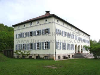
| Charged
with finding or building a field headquarters site for Hitler, architect
Albert Speer reworked a country palace at Ziegenberg, near Bad Nauheim
in Hessen. Modern communications equipment was installed, in addition to
well-appointed quarters, and various above and below-ground bunkers.
This complex was called Führerhauptquartier "Adlerhorst"
(Eagles Nest). But when Hitler saw it, he considered it to be contrary
to his desired appearance as a simple field soldier (he considered it
far too lavish), so another headquarters was built in the Eifel, called
"Felsennest" (Rocky Nest), and this is where Hitler directed
the attack on the West in May 1940 (see above). During the Ardennes Offensive
(Battle of the Bulge) in December 1944, Generalfeldmarschall von
Runstedt used the Ziegenberg facility as his headquarters (Hitler used a small
bunker facility about a mile north in Wiesental - see below). The Ziegenberg complex
was bombed by the Americans shortly before the end of the war. (Bundesarchiv
Koblenz) |
|

|

|
| The bunkers built
near the Ziegenberg palace had both above and below-ground components, and
were camouflaged to look like civilian buildings (these bunkers are used
today as a depot for the German Bundeswehr). (U.S. Army photo) |
|

|

|
| On the
left, an air-raid
protection bunker in Ziegenberg. This concrete bunker was clad on the
outer walls with rough rocks (complete with fake windows), and it had a
pointed roof (originally thatched), as camouflage. Nearby is a
large garage built to service the vehicles of the military staff - now a
business center. (Thanks to Neil Albaugh for info on this site.)
(MapQuest
Map Link) |
|

|

|
| Hitler's
nearby headquarters at Wiesental consisted of several wooden buildings
with underground bunkers. On the left is a wartime photo of one of these
buildings. The above-ground parts are all gone now, with post-war houses
built in their places. Some of the foundations of these post-war
buildings are apparently from the original structures. The large
building in the photo on the right sits where the Reichsicherheitsdienst
(Security Service) bunker was located. The buildings behind are located
on the sites for the bunkers for staff generals, adjutants, and press
personnel. An artist studio now occupies the former location of Hitler's
bunker. (Bundesarchiv Koblenz) (MapQuest
Map Link) |
|

|

|
Above - U.S.
Army personnel examine the remains of the Wiesental bunker complex in
March 1945. (U.S. Army photos)
Below - ruins of the Wiesental bunkers in 1945. (courtesy
Nigel Shipp) |
 |
Click here to see the
Führerheadquarters "Wolfschanze" in East Prussia (now Poland).
Bunkers in Giessen
(Hessen)
|

|

|

|
| Eight
air-raid shelters of a unique style can be found in Giessen. These so-called Winkeltürme
(Winkel Towers) were cone-shaped concrete towers designed by Leo Winkel of Duisburg.
Winkel patented his design in 1934 and began construction in 1936. Eventually some 98
Winkeltürme of five different types were built. The towers were intended mainly as
protection for factory workers and railroad personnel, and they appeared most often in
areas of heavy industry and rail centers. The Giessen towers were installed
on Wehrmacht posts - the one above was on the Artillerie-Kaserne, which
the U.S. Army used as Pendleton Barracks after the war. The tower is now
located on public property and is used as a climbing tower (hence the
brackets added near the top and the knobby projections on the side). The photo on
the right shows damage from a high-explosive shell above the upper door,
and the original locking mechanism on the door. (Google
Maps link) |
|

|

|

|
| The
Winkelturm on the left is near the one in the photos above - it has been
painted as part of a children's recreation center in the adjacent former
barracks building. The two on the right were in the Verdun-Kaserne,
which the U.S. Army used as Rivers Barracks. |
|

|

|
| On the
left, a 1937 postcard showing the Wald-Kaserne, or Verdun-Kaserne in
Giessen. The Winkel towers do not show in these views. Both of these
towers were built adjacent to barracks buildings. (Google
Maps link) |
 |
 |
 |
| Four
other Winkeltürme are
located on the former Berg-Kaserne in Giessen. The close-up views below
show ventilation ports in the sides of the towers. Click here
to see Winkeltürme in Stuttgart, Kaiserslautern, Darmstadt, and
Ludwigshafen; and here to see Winkeltürme in Zossen near Berlin. (Google
Maps link) |
 |
 |
 |
 |
 |
| Inside
one of the Giessen Winkel towers, on the former Verdun-Kaserne. The
different levels were numbered for the appropriate number of people who
could shelter there, and the benches that went around the periphery had
numbers for assigned seating. The photo on the right below shows one of
the original ladders and part of the ventilation equipment. (photos
courtesy Greg Pitty) |
 |
 |
|
|
|
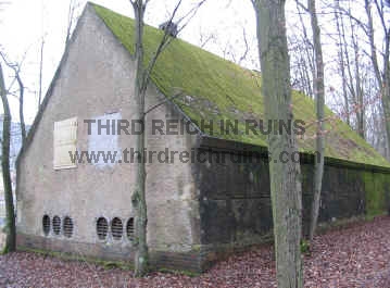
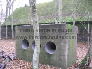
| Part of
the wartime function of the Verdun-Kaserne was to train
Nachrichtenhelferinnen - female auxiliary signals specialists. This
concrete bunker building was part of the "Amt Gisela"
communications complex, located at the rear of the Kaserne. This bunker
complex (including the nearby "Hansa" bunkers) included
underground components - the photo on the right shows a protected
ventilation inlet/outlet for the underground portion beneath this
building.
Further info (in German), including guided
tours, at http://www.bunkermuseum-hansa.de/index.html.
|
-
|

|

|
| To
celebrate its 650th year, the town of Windecken (near Hanau in Hessen)
held a festival with parade on 6-8 August 1938. The town was decorated
with Nazi flags, and the local Kreisleiter was the master of ceremonies
for the festivities. Here, the volunteer fire department participates in
the parade through the Marktplatz. The buildings appear almost identical
today. (period photos and info from the webpage of the
Windecken History Club, http://www.geschichtsverein-windecken.de/orte_im_wandel/650jahrfeier_1938/index.html) |
|

|

|
| Many of
the parade participants were in period costumes, representing various
eras in the town's history. Here, women in Rococo dress walk into the Marktplatz
from Friedbergerstraße. |
|

|

|
| Looking
out from the Marktplatz down Friedbergerstraße, toward the church.
(MapQuest
Map Link) |
-
|

|

|
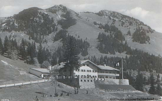
 |
| Nearby,
also on the Sudelfeld near
Bayrischzell, was a Ski School for the Police, built from 1933-42. It is
used today as a mountain training area for the Polizei. (Gerdy
Troost, "Das Bauen im neuen Reich," Part 2, 1942; period
postcard, 1939) (Google
Maps link) |
|

|

|
| These
concrete blocks are bases for towers of a cable car system to transport
materials up to the hill from the valley below (it has also been
theorized that they may be mounts for antenna towers). There are three
sets of these bases running up the hill to a point near the concrete
"mirror." |
-
|
|

|
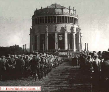
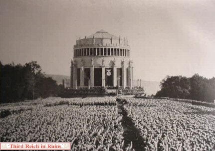
| On 23
October 1933 the Befreiungshalle at Kelheim, overlooking the Danube
River southwest of Regensburg, was the scene of a Nazi gathering of SA
(Sturmabteilung) units. The Befreiungshalle was a monument erected
1842-1863, to mark the liberation of Germany from Napoleonic rule.
(MapQuest
Map Link) |
|

|
|
|
Two views of the same rally as seen from an
elevated position. ("Der Staat der Arbeit und
des Friedens - Ein Jahr Regierung Adolf Hitler" (The Land of Work
and Peace - One Year of the Administration of Adolf Hitler),
Altona-Bahrenfeld, Cigaretten-Bilderdienst, 1934) |
-
|

|

|
| The
Nazis held a parade through the Bavarian town of Vilsbiburg in 1927 in
preparation for a speech by Hitler - SS chief Heinrich Himmler is seen
leading the column. The scene today appears almost identical. ("Adolf
Hitler - ein Mann und sein Volk" - Special Edition of the
"Illustrierter Beobachter," Munich, 1936) (MapQuest
Map Link) |
-
 |
 |
|
SA units parade in Coburg in 1931, with the Vesta Coburg fortress in the background. ("Kampf
um's Dritte Reich," Altona-Bahrenfeld, Cigaretten-Bilderdeinst,
1933; modern view courtesy Christian Gleicke)
|
|

|

|
| A group
of young girls parade in the Coburg Hauptplatz (market square), giving the
"Hitler-Gruß" salute and singing the
"Horst-Wessel-Lied," the unofficial anthem of the Nazi Party.
The occasion was the 75th anniversary of the German gymnastics
association in Coburg, 1936. The modern views show a slightly wider angle to show more of the
surrounding architecture, including the statue of Prince Albert of
Saxe-Coburg, who married Queen Victoria of Great Britain (seen in the
modern view below). (National Archives, RG 208) (MapQuest
Map Link) |
|

|

|
 |
 |
| Soldiers
of the U.S. 71st Infantry Division guard German prisoners of war in
Coburg in April 1945 (compare to the first 1936 view above). ("History of the 71st Infantry
Division," 1945) |
 |
 |
 |
 |
| Tanks
from the 761st Tank Battalion (an African-American unit) move into the
Coburg Marktplatz on 11 April 1945 (compare to the second 1936 view
above). (U.S. National Archives,
RG111SC) |
-
|

|

|
| A
Hitler-Jugend-Heim with Jugendherberge was built in Aschaffenburg in
1935. Post-war construction precludes an overall view of the building
now - this is a composite photo. (courtesy Karl Asmus) (MapQuest
Map Link) |
|

|

|
| The
building now serves as a music school. There have been a few changes to
the outside of the building, including the removal of the
eagle-and-swastika Hoheitszeichen from the front entry
archway. (courtesy Karl Asmus) |
-
|

|

|
| A Munitionsanstalt
(Muna), or ammunition storage depot, was built near
Oberwildflecken in northwestern Bavaria, adjacent to a munitions factory
built ca. 1939, near the Wildflecken
Training Area. After the war, the U.S. Army blew up the ammunition
storage bunkers, which remain today in a ruined condition in the
woods. (Check the Contents
Page for links to other Munas found on the "Third Reich in
Ruins" page.) (MapQuest
Map Link)
|
|

|

|
| Entering
the doorway (left), and inside the bunker interior (right). Only the
side walls and roof edges remain - the centers have been collapsed by
demolition. |
|

|

|
| Looking
back toward the entrance from the inside (left), and a concrete top to a
ventilation shaft (right). |
-
|

|

|
| One of
the largest Munas in Germany was built at Oberdachstetten, near Ansbach
in Middle Franconia. This site consisted of two ammunition assembly
buildings to manufacture primarily 20mm aircraft cannon rounds and 88mm
anti-aircraft and armor piercing rounds, with some 125 munitions storage
sheds and bunkers. Most of these structures were blown up by the U.S.
Army after the war, and many of the ruins were later removed, but some
intact bunkers are still in use by the U.S. Army and some ruins remain.
One of the assembly buildings remains - these buildings are often
described as being built in the shape of a swastika, and such a shape is
evident in aerial views, but in reality, the buildings were built of
four side wings around a central wing, connected by corridors
(superficially resembling a swastika) to separate the manufacturing
processes in the different wings so that an explosion or fire in one
wing would not destroy all the rest. The building now houses the Muna-Museum
of the Verein für militärische Heimatsgeschichte Frankenhöhe e.V.
(which is open to the public - check their webpage for schedules).
(Google Maps
link)
Above - The Muna garrison marches out the main
gate of the adjacent Kaserne (Muna-Museum).
Below - The separate wings of the munitions assembly buildings still
have their original iron doors and window shutters, further protection
to stop the spread of fire from adjacent wings. (Google Maps
link)
|
 |
 |
-
|

|

|
| One of
the work projects completed by the Reichs Arbeitsdienst (RAD - Labor
Service) in the 1930s was the Hochrhönstraße, or High Road
through the Rhön Highlands in northern Bavaria, near the border with
Hessen and Thüringen. Several RAD camps were erected in this area to
house the workmen - the largest of these was a double camp built at the
northern edge of the Schwarzes Moor area near Fladungen. This
camp, for RAD battalions 5/283 and 6/283 (later 1/288 and 2/288) was
called the Dr. Hellmuth-Lager, for the Gauleiter of Main-Franken, Dr.
Otto Hellmuth, who was in charge of the plans and construction in this
area.
The camp consisted of a double row of barracks
buildings with a dining hall at one end and a large training and
exercise hall at the other, the whole being surrounded by a high earthen
berm. The camp was entered though an archway of natural basalt stones,
native to this area, built into the front of the exercise hall. This
basalt archway, seen in the photos above, is the only part of the camp
still standing (remains of the building foundations and the border berm
can also be seen). During World War II the camp housed prisoners of war
who worked in the nearby fields. The buildings housed displaced persons
after the war, and the camp was later torn down. (period photo
in author's collection) (MapQuest
Map Link) |
|

|

|
| The
large exercise hall (9000 square feet) can be seen in the overall view
of the camp, along with the berm surrounding it. The road in the
foreground is the Hochrhönstraße. The modern photo was taken
inside the site of the exercise hall, showing the inner side of the
entry archway, and part of the earth berm remaining in the distance.
(period photo in author's collection) |
|

|

|
| Other
RAD camps were built in the nearby area - this is the
"Tal-Lager" camp for RAD Battalion 3/288, built in 1938
adjacent to Fladungen. The RAD workers also built a monument of basalt
rocks on the Heidelstein hill near the Hochrhönstraße. This was
demolished in 1964 for the erection of a radio antenna. (period
photos in author's collection) |
|

|

|
| This
building was built in the mid-1930s at the southern end of the
Hochrhönstraße, as the Hitler Jugend Heim Bauersberg. It now serves as
a youth education center. (MapQuest
Map Link) |
-
|

|

|
| The
Baldur von Schirach Jugendherberge (youth hostel) was built above the
Walchensee lake in southern Bavaria in 1936, named for the leader of the
Nazi youth movements. The building still serves as a youth center, but
vegetation has grown up all around it making a modern comparison view
impossible. (Gerdy Troost, "Das Bauen im neuen Reich"
(Vol. 1, 1942 ed.) (MapQuest
Map Link) |
|

|
This small pressed paper
disc portrays the Baldur von Schirach Jugendherberge. It was one of a
series showing youth hostels across Germany, given as a token to those
who contributed to the Winterhilfswerk Nazi welfare relief.
(author's collection)
Click here to see
a WHW disc showing the Adolf Hitler Jugendherberge in Berchtesgaden. |
-
|

|

|
| Julius
Streicher, the Gauleiter of Franken, fell out of favor with the Nazi
leadership in 1940 and retired to his manor farm, the
"Pleikershof," near Cadolzburg, west of Nürnberg. Streicher
was executed in 1946 as a result of the Nürnberg Trials - after the war
his farm was
used as housing for displaced persons and later for freed concentration camp
prisoners. The property is now in private ownership. (MapQuest
Map Link) |
 Continue to Part 4
Go to the War Memorials page
Back to the Third Reich in Ruins homepage
|