Geoff Walden


Home ] Up ] Miscellaneous Sites Part 2 ] Miscellaneous Sites Part 3 ] Misc. Sites Part 4 ] Miscellaneous Sites 5 ] Misc Sites Pt. 6 ] Misc Sites 7 ] [ Miscellaneous Sites Pt. 8 ] Misc. Sites Pt. 9 ]


Miscellaneous Sites

Associated with the Third Reich

Part 8


   The following sites can be found on this page: SS Kaserne for Standarte "Germania" at Radolfzell am Bodensee (Baden-Württemberg), Haigerloch Atomkeller (Baden-Württemberg), Reichsthingstätte at Bückeberg and U-Boat Bunkers in Bremen (Niedersachsen, Lower Saxony), Hermann Denkmal (Nordrhein-Westfalen), Hitler Park, Germersheim (Rheinland-Pfalz), Ellingen (Bavaria), Dietrich Eckart Erholungsheim, Augsburg-Biburg (Bavaria), Augsburg (Bavaria), Landsberg (Bavaria), Schlageter Memorial, Schönau im Schwarzwald (Baden-Württemberg).


A Kaserne for SS-Standarte "Germania" was built on the outskirts of Radolfzell am Bodensee (Lake Constance) in 1935-37. Standarte "Germania" later supplied most of the SS concentration camp guards and also the combat units that became the 3rd SS Panzer Division "Totenkopf" in the Waffen-SS. The building complex is now owned by the city and various businesses. The main Staff Building (seen here) has been considerably changed, but the SS entrance guard houses remain, as do the SS barracks buildings and the gymnasium. The official name of the barracks complex was Heinrich Koeppen Kaserne (Koeppen was the commander of the 3rd Battalion of SS-Standarte "Germania"). During the war the Kaserne served as a training center for SS cadets.  (period postcards) (Google Maps link)


Various other Kaserne buildings still exist at the site, such as the "Führerheim" (left) and the SS housing tract, both of which appear to be inhabited by refugees now.


A monument to the World War I dead of Radolfzell was erected in 1937 (dedicated in 1938) in the Luisenplatz, then known as the Horst Wessel Platz. The monument came to be called the "SS Monument" as the soldiers of Standarte "Germania" were fully involved in its dedication. After the war, the eagle and swastika were removed from the wall behind, along with the inscription below the soldiers, "The City of Radolfzell to its Fallen Heroes of the World War 1914-1918."  (period postcards) (Google Maps link)

-

A large Schießstand (shooting range) complex was built outside Radolfzell for weapons training of the SS troops. The range was started in 1938, but was completed and enlarged in 1941-42, using labor of concentration camp prisoners. The range consisted of three 33 meter pistol ranges, three 300 meter rifle ranges, a target changing bunker, and an ammunition storage building. Two of the concrete pistol range backstops appear above; the one on the right has a memorial sign to the concentration camp prisoners. On the left below are SS trainees at the range in the winter of 1942-43. On the right below is an intermediate backstop on the rifle range.  (below - Große Kreisstadt Radolfzell am Bodensee& Projektgruppe "Radolfzeller Gedenkstätten") (Google Maps link)


The 300 meter rifle range had a large concrete backstop (the front face was originally covered with wood, and the backstop was filled with sand, which was removed a few years ago). The metal covers seen in the space just in front of the backstop cover the holes through which targets were raised and lowered. This task was performed by soldiers in a concrete bunker beneath. Several of the target mechanisms in this bunker, although rusty, still operate.


Haigerloch Atomkeller

1n 1943 research Professor Walter Gerlach moved his atomic energy experiments from Berlin to a cave (beer cellar) in Haigerloch, to protect his facilities from bombing attacks. Experiments here attempted to make a nuclear reactor using uranium, but these attempts were incomplete at the end of the war. Americans dismantled the complex in 1945. These period photos show the soldiers removing the graphite blocks from the reactor. The museum display in the cave partially recreates the reactor, with replica uranium cubes hanging above.  (U.S. National Archives) (Google Maps link)


Bückeberg Reichsthingstätte

The so-called "Reichsthingstätte" or "Reichs Thingplatz" was built on an open hillside of the Bückeberg hill, near Hameln (Hamelin) in 1933 (with later expansions and improvements). Although it was called a "Thingplatz," the purpose was originally solely for the annual Erntedankfest, or harvest thanksgiving festival. This huge fall fest saw attendance as large as a million people - these period photos give some idea of the size of the crowds. Designed by architect Albert Speer, the site was laid out in an oval surrounded by flagpoles, with a speakers platform on the lower end and a grandstand for guests of honor (Ehrentribüne) on the upper end, near the top of the hill. A special Führerweg pathway for Hitler linked the two platforms. This path was raised above the surrounding ground and paved with gravel, and its grassy remnant is the most recognizable feature of the site today.  (Google Maps link)

In the photo above, Hitler is climbing the steps of the speakers platform at the lower end, during the 1934 festival (1 October). The corresponding view, looking toward the top of the hill, is necessarily taken at ground level as there is no trace today of the raised speakers platform. In the photo below, Hitler greets the crowd as he climbs the Führerweg from the speakers platform (the white structure seen at the bottom of the hill) to the Ehrentribüne, on 3 October 1937.  (above - "Adolf Hitler" (1936); below - Hoffmann Photo Collection, U.S. National Archives)


The 1937 photo above gives a good view from the speakers platform, up the hill via the Führerweg, to the Ehrentribüne at top (with massed flagpoles). The 1935 view below is from the edge of the site, looking down toward the speakers platform.  (above - Hoffmann Collection; below - Bundesarchiv)


In 1935 a group of Pzkw. I tanks (probably from Panzer Regiment 1) participated in a military demonstration. The commander is riding in the turretless command version at the right. These photos give good overall views of the site, then and now. The Ehrentribüne can be seen at the top of the hill.  (Bundesarchiv)


Concrete supports for the wooden Ehrentribüne grandstand exist today in the woods at either side of the Führerweg at the top of the hill.


Above - Several concrete boxes for electrical conduits and wiring for lights and loudspeakers can be found along the Führerweg. Below - A cobblestone roadway was built from the nearby village of Hagenohsen up the side and back of the Bückeberg hill, to reach a parking area behind the Ehrentribüne (the ruins of the Ehrentribüne are in the trees seen in the distance in these photos).


Bremen U-Boat Bunkers "Hornisse" and "Valentin"

The inland port city of Bremen was the site of two U-Boat bunkers on the Weser River. "Bunker Hornisse" (Hornet) was located in the main harbor area directly on the river. This fortified concrete structure was designed for constructing sections of the Type XXI U-Boat, which when completed would be shipped down the river for final assembly at "Bunker Valentin" (see below). "Bunker Hornisse" was started in March 1944 but was not completed by the end of the war - no U-Boat construction took place there. The bunker, which had been built using forced labor and slave labor from a concentration camp, was bombed by the U.S. 8th Air Force on 30 March 1945. A multi-floor office building was built on top of part of the bunker in the late 1960s.  (Google Maps link)


The major U-Boat bunker in Bremen was "Bunker Valentin," built near the village of Rekum some 15 miles down the Weser River from the Bremen harbor. Like "Bunker Hornisse," "Bunker Valentin" was built using forced labor and concentration camp labor. "Bunker Valentin," one of the largest concrete building projects of the Third Reich, was designed for final assembly and launching of Type XXI U-Boats. Construction started in the summer of 1943 - the photo on  the left above shows the site in the summer of 1944 - but the bunker remained unfinished at the end of the war and no U-Boats were ever built there. The doorway seen in the photo at lower right would have allowed access to and from the Weser River through a short canal. The finished U-Boats would have been launched through this doorway, which could be closed by large armored metal doors.   (Bundesarchiv)  (Google Maps link)


The photo on the left above shows the interior of the U-Boat launching area through the outer doorway to the Weser River (the river is behind this perspective). The walls and roof of steel-reinforced concrete are 4.5 meters (15 feet) thick, except for part of the roof that is 7 meters (23 feet) thick, which was the planned final roof thickness after addition of more concrete slabs.


The interior of "Bunker Valentin" appears today in two sections - one part that is more-or-less as it appeared in 1945, including damage from Allied bombing attacks using "bunker buster" bombs in March 1945 and post-war anti-bunker bomb testing, and the other part that was renovated by the Bundesmarine in the 1960s and used as a storage depot until 2010 (seen below). The raised area of the ceiling in the photo on the right below was a special area made to allow test raises of the U-Boat periscopes and snorkels.
Click here to see a photo of damage to "Bunker Valentin" made by a British "Grand Slam" bunker buster bomb in March 1945.


The Cathedral (Dom) in Bremen was decorated with swastika banners and banners reading "Es lebe unser Volk!" and "Es lebe unser Reich!" (Long Live Our People, Long Live Our Country!)


Hermanns Denkmal, Teutoburger Wald

In 1875 a monument was inaugurated to the victory of the Germanic chieftain "Hermann" (Arminius) over Roman legions in the nearby Teutoburg Forest in 9 AD. The monument was popular with visiting German units during the 1930s and 1940s. The unit seen posing here was probably a Feldgendarmerie or military police unit. The monument also featured in Nazi propaganda postcards; the inscription below reads "Where once the leader of the Germans liberated the German land from the enemy, Hitler's victory flag waves powerfully in the new era." (see also here(above - Wikipedia Collection; below - author's collection)  (Google Maps link)


Hitler Park, Germersheim

The period postcard depicts the Hitler Park in Germersheim on the Rhein River (the stone in the foreground read HITLER PARK with a swastika). The lake is called the Schwanenweiher (Swan Lake) today. The site is a little changed, and reeds now obscure much of the miniature castle on the island.  (Google Maps link)


Hitler visits Ellingen, Bavaria

During his motor travels throughout Germany in the early 1930s, Hitler's car passed through the Franconian town of Ellingen. The view at the Pleinfelder Tor remains remarkably similar today.  (Heinrich Hoffmann, "Hitler wie ihn keiner kennt," Berlin, 1932)  (Google Maps link)


Dietrich Eckart Haus Erholungsheim, Biburg

A relaxation and recreation home for the Labor Front (DAF - Deutsche Arbeits Front) was built outside the village of Biburg near Augsburg. The home was named for Hitler's mentor Dietrich Eckart. The building, which apparently has changed little, has long been unused and dilapidated, and is surrounded by a fence and trees, making photography difficult today. (Click here and here to visit other sites associated with Dietrich Eckart).  (period postcards)  (Google Maps link)


Augsburg

Maximilianstraße in the Bavarian city of Augsburg was decorated with Nazi flags in March 1933. In the distance is the Rathaus and the Perlach Tower.  (Google Maps link)


Landsberg am Lech, Hitler's Prison

  Following the abortive Munich putsch of 9 November 1923, Adolf Hitler was tried and sentenced to a term in Landsberg prison. Hitler served only some nine months of the five year sentence, from April-December 1924. Upon his release on 20 December 1924, his photographer Heinrich Hoffmann was present to record the event, but the authorities would not allow a photo of Hitler leaving the prison. So the party drove to the other side of the town and staged a photo opportunity showing Hitler at the Bayertor city gate (above). As Chancellor of Germany, Hitler visited in 1934 for another posed photo in the same location (below).  (U.S. National Archives, RG242)  (Google Maps link)


  A 1939 English edition of Hitler's book Mein Kampf erroneously identified the Landsberg Marktplatz as the location of the prison, where Hitler wrote the first part of the book.  (Google Maps link)


The Landsberg prison is actually located on the other side of the Lech River from the old part of the town shown above. Hitler's cell was in a small wing near the west end of the prison (two windows circled above). The view above was taken in the adjacent prison cemetery, which was used after the war to bury former SS members who had been convicted and executed by the Allies. The view below shows how the prison was decorated during the Third Reich period. This wing of the prison is very difficult to see today from outside the prison - the zoomed view below is taken from about the closest area that one can legally approach the prison grounds on this side. The windows of Hitler's cell are circled (the sixth window on the right was filled in at some point after the war).  (Bundesarchiv)  (Google Maps links - cemetery, modern photo site below)


Postcard views of Hitler's cell were popular during the Third Reich period. The view on the left below is often labeled as showing Hitler in his cell (although not in the original publication, where the photo is uncaptioned), but the details of the room and the fact that another wing of the prison can be seen through the windows prove that this photo was taken in a different area. The view on the right below shows the common room or dayroom where Hitler and other prisoners took their meals.  (above right - "Ich Kämpfe," Munich, 1943; below left - Heinrich Hoffmann, "Hitler abseits vom Alltag," Berlin, 1937: below right - Otto Lurker, "Hitler hinter Festungsmauern," Berlin, 1933)  (Google Maps link - prison wing with Hitler's cell)
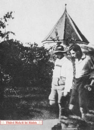
 

On the left, Hitler (in Lederhosen) takes his daily walk along the prison inner wall with his prison mate and first chauffer Emil Maurice. On the right, Hitler visits the site in October 1934 with Maurice and his adjutant (and former prison mate) Julius Schaub.  (left - Otto Lurker, "Hitler hinter Festungsmauern," Berlin, 1933; right - period postcard)


On the left, Hitler's jailor Oberwachtmeister Franz Hemmrich, stands at the main gate to the Landsberg prison. The modern photo shows the entire gatehouse. (period photo - Heinz A. Heinz, "Germany's Hitler," London, 1934; modern photo courtesy Neill McDonough)  (Google Maps link)

Click here to see a ruined explosives plant near Landsberg.


Schlageter Grave and Monument

Albert Leo Schlagter was an officer in the German Army in World War I, who was active in Freikorps circles after the war and opposed the French occupation of the Ruhr area of Germany. He was captured by the French and executed near Düsseldorf on 26 May 1923. Schlageter was treated as a martyr and nationalist hero during both the Weimar Republic and the Third Reich, and his grave in his hometown of Schönau im Schwarzwald became a Nazi shrine. (Schönau im Schwarzwald (Black Forest) is not to be confused with Schönau am Königssee, near Berchtesgaden.) 

Schlageter's grave marker was defaced after the war, removing the column and his name and changing the shape of the marker. The original marker is still on the grave, with a more modern plaque giving Schlageter's information. A memorial obelisk can be seen on the hillside beyond the grave (see below).  (period postcards)  (Google Maps link)


In 1926 a memorial obelisk to Schlageter was erected on the Letzberg hill overlooking Schönau. The obelisk was removed post-1945; only the base remains today (some sources say the obelisk was removed in 1937 during construction of a larger adjacent memorial).  (period postcards; center right - "Illustrierter Beobachter," 26 May 1938)  (Google Maps link)


In the late 1930s a much larger Schlageter monument was begun just behind the memorial obelisk on the hill. Ruins of this monument, including interior spaces, still exist.


   Proceed to Misc. Sites, Part 9

   Go to the War Memorials page

   Back to the Third Reich in Ruins homepage


Third Reich in Ruins, http://www.thirdreichruins.com/

All contents copyright © 2000-2021, Geoffrey R. Walden; all rights reserved.  All photos taken by or 
from the collection of Geoffrey R. Walden, except where specifically noted.  Please respect my property rights,
and the rights of others who have graciously allowed me to use their photos on this page,
and do not copy these photos or reproduce them in any other way.

This page is intended for historical research only, and no political or philosophical aims should be assumed. 
Nothing on this page should be construed as advice or directions to trespass on private or posted property.

The appearance of hyperlinks does not constitute endorsement by the author of the information, products or
services contained in any hyperlinked web site herein, and the author does not exercise any editorial control
over the information you may find at these locations.

This page initially uploaded on 20 July 2000.