|
Obersalzberg
Bormann's Gutshof (manor
farm) and Hitler's Teehaus
(Click here
to proceed directly to the Teehaus.)
Since Reichsleiter Martin Bormann
was interested in farming, he built an experimental farm as part of the Obersalzberg
complex. Although this farm was to serve as a model for other farms in the Third Reich, it
was never particularly successful. Bormann's farmers raised cattle, horses, and pigs here.
The Gutshof complex also included bee houses, waterworks buildings, a smithy, and
various other structures in the pastures and meadows. The main buildings were not substantially
damaged during the April 1945 bombing, and the main part of the farm was appropriated by
the American forces and turned into a sports lodge and golf course, with skiing in the
winter. Since the Americans left the Obersalzberg in 1995 the Gutshof has
functioned as a golf club and restaurant. In the fall of 2007 the side building
(seen on the right in the photos below) was torn down.

|

|
Administrative and residence
buildings of the Gutshof
(Hartmann, "Verwandlung") |
Same view in recent
times. The buildings now
house a golf club and restaurant (the taller wing at the right was torn down
in 2007). |
 |
 |
| During
and after the side building destruction. The area is now a putting green
for the golf course. The view on the right looks down the length of the
Gutshof complex (this view would have been impossible during the Third
Reich period, as the side wing sat right here). |


|

|
Farm buildings of the Gutshof,
then and now. (Hartmann, "Verwandlung") |
 |
 |
 |
 |
| On the
left, a view of the Gutshof from the meadow side in the winter, from Eva
Braun's personal photo albums. The Watzmann mountain is in the
background. On the right is the entrance to the wing of the Gutshof that
housed the staff, with its original wooden door. (This building was torn
down in October 2007.) (National
Archives, RG 242-EB, 20-41B) |
 |
 |
| The original Gutshof
building plaque - several of the Obersalzberg buildings had similar
plaques. This one was saved from the 2007 destruction, and is now
mounted beside the entry doorway to the golf club. |
 |
 |
| The
electric clock and associated bell which were originally mounted on the
wall of the side wing that was torn down in 2007, were also saved and
were later installed on the main surviving building, near the
entryway to the golf club. |
 |
 |
| Views of
the back and side of the main Gutshof building, showing the massive
construction. |
 |
 |
| Interior
of the former Gutshof barn and cattle stall areas. |
 |
 |
 |
| Original
architectural pieces that can be found in the Gutshof today - left, a
fodder stall; center, one of the heavy oak beams that support the
ceiling; right, a stone water basin. |
-
 |
 |
| Due to
its use as a dairy farm, the Gutshof had its own sewage and waste water
treatment plant (Kläranlage). This facility is not in use today,
but it remains mostly intact, including some of the original flow
control valves and activators. On the right below is what appears to be
an original long-handle scoop. |
 |
 |

|

|
The Gutshof complex
from the rear. The period photo shows the famous Watzmann mountain towering in the
background; the modern photo is from a slightly different angle. The meadow area is now a
golf course. The perspective below shows a good view of Albert
Speer's house on the hillside beyond. (National Archives, RG 242-HB) |
 |

This picture taken by Eva Braun shows a
similar perspective of the Gutshof, with the mountains in the
background. This photo is interesting because it shows some of the Gutshof
outbuildings that are rarely
seen in period photos. At the left center of this view can be seen the pig sty (Schweinestall
or Zuchtstall)
- a low white
building at the edge of the photo - with the larger hay barn (Heuscheune)
next to it. Today there are no remains
of the Heuscheune, and only a few rubble remains of the Schweinestall. (National
Archives, RG 242-EB, 11-11C)
 |
 |
| The deep
valley in front of the Gutshof was crossed by an elaborate stone bridge,
one of many of similar construction in the Obersalzberg area. |
 |
 |
 |
| The Gutshof area as
seen in a pre-war aerial film, and as photographed by a
U.S. reconnaissance plane in May 1945. The Gutshof itself suffered little
damage,
although a bomb did hit the building on the left side in these views (several
other bomb craters can be seen scattered about the
area). The buildings across the road from the Gutshof were the pig sty and hay
barn - the hay barn took a direct bomb hit.
At the top right edge of the 1945 photo is Albert
Speer's architectural studio. (U.S. National Archives) |
 |
 |
| The pig sty
(Zuchtstall) and hay barn,
as shown on a 1941 Obersalzberg map. The hay barn had
two stories, with ramps leading up either end so hay wagons could be driven into
the upper floor. On the right is a view of the hay barn after it was damaged by
the 25 April 1945 bombing attack. |
 |
 |
| The
ruins of the pig sty could be seen on the Obersalzberg until the
mid-1990s, when they were removed. Only a small amount of rubble can be
found on the site today. (above - courtesy Ana L. Jackson;
below - courtesy Adrian Harvey) |
 |
 |
 |
 |

|

|
| The
building on the left, located on part of the Antenberg Hill above the Platterhof (there
are two such buildings located there), is said to have served
as a cooling house for the milk of the Gutshof herds, until it was bottled.
The building on the
right, located at the entrance to the Scharitztkehlalm pasture area, is
identified as a Wasserhaus on the original building plans, and it
would have been about twice as large as the low building seen today. It
may have been a pump house for water control in the Scharitzkehl valley. |
-
 |
 |
 |
| The
Scharitzkehlalm is a mountain pasture at the foot of the Hoher Göll and
surrounding mountains (the Kehlsteinhaus
is on the mountain to the left of the view above - not seen in this photo).
Martin Bormann appropriated it as a pasture for the Gutshof cattle
herds. The Nazis installed elaborate water systems (seen in the
foreground above), and even paved some of the stream bed running through
the valley, including artificial steps. The stream was bridged with
typical Obersalzberg construction. (Florentine Hamm,
"Obersalzberg - Wanderungen zwischen Gestern und Heute,"
Munich, 1941) |
 |
 |

|

|
| A tunnel dealing with the Scharitzkehl
waterworks is located in this area.
The date 1942 appears above the entrance, which is across the road from
the entrance to the Scharitzkehlalm. The tunnel runs beneath the road near
the bridge seen above, and ends at this metal covered shaft near the Wasserhaus. The tunnel gives access to a large water pipe running
underground here. |
 |

An original milk bottle from the Gutshof
dairy (author's collection)
-
 |
 |
| Another
hobby occupation of Bormann's was bee-keeping, and he had at least two
large bee houses built on the Obersalzberg. The Bienenhaus seen
here was built at the edge of the Lenzerfeld meadow west of the Gutshof, and its
ruins can still be found today. Note how the ruins still show the curved
walls of the outer wings, seen in the 1945 aerial photo above. This bee
house was not hit during the April 1945 bombing attack, but it was
probably demolished in the early 1950s along with other Obersalzberg
buildings. The other bee house was built in the Landlerwald area of the
Kehlstein foothills, and its cellar is also extant (click here
to see photos). (many thanks to my friend Ralf Hornberger for
some of the ruins photos; 1945 photo from the U.S. National Archives)
(Note - These ruins were largely demolished/buried in October 2016.) |
 |
 |
 |
 |

|

|
| The
original metal gate for the Bienenhaus still exists, in a somewhat
dilapidated condition. (removed in
2016) |

|

|
These
stone pillars formed a
gate at the Teugelbrunn roadway, downhill from the Gutshof.
The road led back into the meadows behind the Gutshof. A heavy oak gate between the
pillars kept the road normally closed. This gate marked the edge of Bormann's main area of
control, and the remains can be seen today in the woods on the left side of the road as
one climbs toward the Obersalzberg from Berchtesgaden. There was also an SS guard house located
near here, part of
the access control system of the outer Führer security area on the Obersalzberg.
(photo below courtesy Ralf Hornberger) |
 |
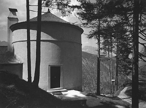
Teehaus on
the Mooslahnerkopf
Besides his Berghof home,
undoubtedly Hitler's favorite place on the Obersalzberg was a cozy Tea House built in 1937
on the northern boundary of the area, just below the Mooslahnerkopf hill, overlooking the
Berchtesgaden valley below. Most of Hitler's stays at the Berghof included a daily
afternoon walk to this Teehaus. This pleasant walk often became the scene for important
political decisions, but Hitler preferred to relax, and even nap, in the Teehaus itself,
surrounded by his closest friends and associates. The Teehaus was apparently undamaged by
the 1945 bombing, but was mostly destroyed ca. 1951, due to its association with Hitler.
The ruins remained in the woods behind the Gutshof golf course,
until they were removed in 2006. (Note -
the 1937 architectural plans for the Teehaus as well as captions in Eva Braun's photo
albums spell the name "Moslanderkopf," but it is generally given as
"Mooslahnerkopf" today, and that is the spelling found on period maps of the
area.)

This view (which appears to be a composite photo)
shows the location of the Mooslahnerkopf Teehaus,
in relation to the more famous Kehlsteinhaus ("Eagles
Nest"), high on the ridge above. The so-called Eagles Nest
is often called "Hitler's Tea House," but this is technically incorrect. Hitler
did not treat the Kehlsteinhaus
as a tea house, and the location he visited daily for afternoon tea was actually the
Mooslahnerkopf Teehaus.
(Ernst Baumann photo)

|

|
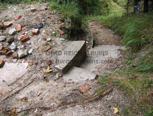
Teehaus seen from near the
overlook. This 2005 view shows the foundation ruins of the
round part of the Teehaus.
Note - all the ruins shown on this page
were removed in August-September 2006. The period view above now looks
like this: |
 |
 |
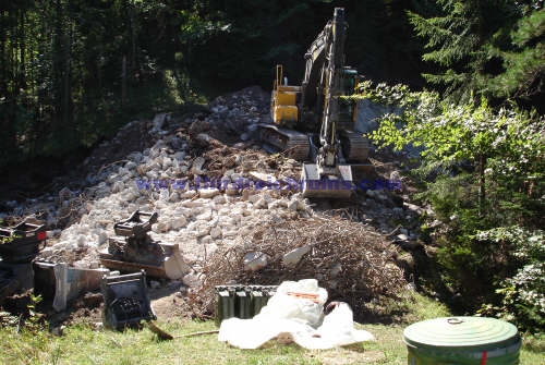 |
| Destruction
of the Teehaus ruins, September 2006. (courtesy Charles Smith) |
 |
 |
| Adolf
Hitler and Eva Braun in the Teehaus. On the right is a view taken from a
U.S. reconnaissance plane in May 1945. The round part (where Hitler and
his guests took tea) can be plainly seen, with the part that housed the
kitchen partly hidden by trees. (U.S. National Archives) |
 |
 |
| Ruins of
the lower portion of the round part of the Teehaus - basement storage
rooms. |

|

|
Ruins of the back part of the
house, which was built against the rock hill. |

|

|
Ruins of the lower part of the
kitchen wing. |
 |
 |

|

|
Roof of the round
part of the Teehaus. The weather vane is said to now be on a building in the valley below.
The modern photo shows one of the chimneys, upside-down and resting on the upper part of the
main building ruins. The chimney retains its original tin liner. (The
chimney seen here is likely the chimney for the kitchen in the main part
of the building, not the fireplace chimney seen in this period photo.) |

|

|
The walk to the
Teehaus featured an overlook above the Berchtesgaden valley, one of Hitler's favorite
views. (National Archives RG 242-H) |
|

|
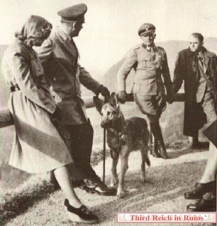
Hitler enjoys the view at the
overlook with Eva Braun, his dog Blondi, Leibstandarte-SS commander Sepp Dietrich, and
architect Albert Speer. (National Archives RG 242-EB) |
Same view today - the
wooden railings had been removed for several years, but were put
back in place just before this photo was taken in May 2004 (apparently for
the filming of a German TV mini-series, "Speer und Er," aired in
May 2005 - this show used several Obersalzberg sites). |
 |
 |
| Above,
Hitler walks with Foreign Minister Joachim von Ribbentrop, in a still
from Eva Braun's movies. Below, a pensive Hitler sits at the overlook,
while an apprehensive-looking Albert Speer gives Hitler plenty of space.
A replica of the bench was put in place here in 2004 for the filming of
"Speer und Er," but it has since been removed and a smaller
version is now on the site. (U.S. National Archives) |
 |
 |
 |
 |
| Hitler
poses at the overlook with his favorite dog Blondi. In the background is
Henriette von Schirach, wife of the Reichs Youth Leader Baldur von
Schirach, and daughter of Hitler's photographer Heinrich Hoffmann.
(US National Archives, RG242) |

This panoramic view of the Mooslahnerkopf overlook
is from a period color photo by Walter Frentz. Hitler,
with Blondi at his side, talks with Foreign Office ambassador Walter Hewel. ("Hitlers
Berghof 1928-1945,"
Kiel, Arndt-Verlag, 2000)

I have received several requests for
information on the exact location of the Teehaus site, as this appears on few
published maps. The Teehaus site and overlook are located in the woods behind
the Gutshof golf course, but I strongly recommend that you do not cross directly
across the golf course to get there; or I suggest you use this route only at
times when the golf course is not being used by golfers. The route shown above is
longer than walking across the golf course, and the first half of it is all
downhill (so it is all uphill going back), but it keeps you from trespassing on
the golf course itself. Begin across the street from the Hotel zum Türken
(lower right) -- walk into the woods and follow the graveled foot path that
slants down the hillside. Follow this path through the woods then across the
open hillside with the ski lift, until you reach an open area where several
paths come together (there is a path sign post and a bench here). At this point, continue downhill to the left, a short
distance, until you see a small dirt path leading off to the left, just beyond
the edge of the golf course. This path goes mainly just inside the woods on the
back (north) side of the golf course (if you start sharply downhill, you have missed the
left-hand turn to this path). Keep following this path through the woods for about
700 yards. When you reach a broad dirt trail, turn right - this leads to
the overlook and Teehaus site (marked by a star on this photo). There are
several different paths going through the woods along this route, but basically,
if you just keep the golf course to your left without actually going out onto
the playing area, these directions will take you to the Teehaus site. But
remember that the ruins shown in these photos are no longer there - they were
removed in August 2006. (aerial
photo © SAGIS) (Google
Maps link)
Click here
to visit a page showing details of the routes used during Hitler's walks to the
Teehaus.
For further information, including Internet links, check
the Bibliography page.
 Continue to other Obersalzberg sites - Hitler's
Berghof, Bormann's and Göring's houses, Platterhof, Gästehaus and Kampfhäusl,
Hotel zum Türken,
Kehlsteinhaus, SS barracks, bunker system,
SS guard houses, miscellaneous buildings,
other miscellaneous area buildings, area Flak
Battery positions.
Continue to other Obersalzberg sites - Hitler's
Berghof, Bormann's and Göring's houses, Platterhof, Gästehaus and Kampfhäusl,
Hotel zum Türken,
Kehlsteinhaus, SS barracks, bunker system,
SS guard houses, miscellaneous buildings,
other miscellaneous area buildings, area Flak
Battery positions.
 Return to the Third Reich in Ruins homepage Return to the Third Reich in Ruins homepage
 |
My guide
book to Third Reich sites in the Berchtesgaden and Obersalzberg area has
been published by Fonthill Media.
"Hitler's
Berchtesgaden" is available at Amazon and other retailers (the
Kindle version is also available from Amazon). |
Guided Tours
For personal guided tours in
English of Third Reich sites in Berchtesgaden and on the Obersalzberg (and other
local sites) from a certified and accredited local tour guide, contact:
Tom Lewis
+49-(0)1602-641-800
atobersalzberg@sky.com

BEGAFILM
- Historic Films About Berechtesgaden and the Obersalzberg
|