|
Obersalzberg
Other Miscellaneous Buildings
 |
 |
| The
Obersalzberg quickly became a popular destination for touring youth
groups, and in 1939 a hostel building was erected for visiting
Hitler Jugend (HJ) and Bund Deutscher Mädel (BDM) groups (click here
to see a photo of one such visit). This Jugendverpflegshaus (or
Jugendpflegeheim) was a wooden
building with kitchens, baths, storage, and other rooms in the basement.
The building was located at the curve on the
Obersalzberg road, downhill from the Platterhof, at the entrance to the
Antenberg area. I have not seen a period photo of this building, only the
artist renditions above. (left - from a 1941 illustrated
map; right - Roderick Fick architectural plan in the Munich Technical
University (TUM) |
 |
 |
| These
two crops from May 1945 U.S. reconnaissance photos show the bomb damage
to the Jugendverpflegshaus. (U.S. National Archives) |
-

|

|
Two housing complexes
were built in the Obersalzberg area for military families and civilian support staff.
These were the Klaushöhe and Buchenhöhe settlements, east of Hintereck. Both areas were
damaged by the April 1945 bombing, but have been partially rebuilt and used as multi-family rentals
since the war (immediately following the war they served as refugee housing). These photos
show the Klaushöhe settlement, for married SS guard members. (Dokumentation
Obersalzberg) (MapQuest
Map Link) |
|

|

|
 |
 |
|

|

|
| My
father photographed the Klaushöhe and Buchenhöhe settlements when he
visited the Obersalzberg in 1946. On the left, a partial view of the
same buildings as seen in the period photo above (compare the building
at the left edge in both photos), with the Hoher Göll mountain behind.
Note the ruined houses in the background. On the right, a view of the
Buchenhöhe ruins in the distance, as seen from the Klaushöhe parking
lot. (photos by Lt. Delbert R. Walden, USAAF, collection of
G.R. and G.A. Walden) |
-
 |
 |
These
two crops from a May 1945 U.S. reconnaissance photo show (left) the Klaushöhe
settlement, and (right) the workers camp that was located between Klaushöhe
and Buchenhöhe (the camp was called Lager Riemerfeld). Various ruins can be found in this area today
(below). The underground water reservoir on the right below is noted by
the red arrow on the 1945 photo above. (U.S. National Archives)
Click here to
see the ruins of the workers camp at Lager Antenberg. |
 |
 |
 |
 |
 |
 |
 |
 |
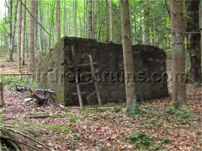
| This
concrete ruin near the Klaushöhe housing area was apparently a water
reservoir, similar to the reservoir
above the Berghof. Its interior was tiled (at least partially). |

An artist's portrayal of the Buchenhöhe
and Klaushöhe settlements, from a 1941 illustrated map of the Obersalzberg. It
should be noted that not all of the buildings shown here were completed or even
started.
-

|

|
The Buchenhöhe
settlement was somewhat larger, for families of the Obersalzberg support staff. The
settlement included multi-family dwellings and community buildings. Many of
the buildings that were damaged in the bombing attack were torn down and
rebuilt, and several post-war buildings are now used as an asthma
treatment center.
The remaining period
buildings on the main street show the unmistakable Third Reich architectural style. |
 |
 |
 |
 |
| This
postcard view from the 1950s shows the Buchenhöhe heating plant
building, still with its camouflage paint on the walls. (author's
collection) |

|

|
Some of
the bombed Buchenhöhe house ruins were not rebuilt or removed, and remained on the edge of the
village for many years (these ruins were removed or buried ca. 2010). |
-

This period photo shows a Skoda-made
Menck & Hambrock excavator in use at the Buchenhöhe site by the construction company Phillip Holzmann AG.
(photo courtesy Andreas Beck & Leo Helmschrott, Beck
& Helmschrott GbR,
source the www.baggerfreunde.de
webpage)
-
|

|

|
| The
Polensky & Zöllner construction firm was responsible for many of
the roadways and bridges in the Obersalzberg area. Their markings can
still be seen on some of the area bridges - this is the bridge over the
Larosbach stream near the Buchenhöhe
settlement. (My thanks to Frau Ingrid Scharfenberg for this
information.) (MapQuest
Map Link) |

|

|
Another of Martin
Bormann's building projects in the area was the Alpenstraße, a scenic mountain road
designed to link Bodensee to the Königssee, through the Bavarian Alps. This Alpine Road
was actually started in 1927, and was not completed until the 1950s, at which time this
1930s portion of the road was bypassed. These remains of the Third Reich period roadway,
including a pedestrian underpass tunnel at a popular hiking trail, can be seen on the
Scharitzkehlstraße southwest of the Obersalzberg, on the way to the Hinterbrand area and
the Scharitzkehlalm. |
 |
 |
-

|
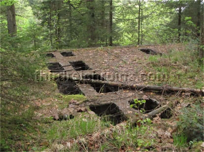
The
workers camp Lager Dürreck was located just downhill from the road
section shown above. The workers here built roads and tunnel systems.
Although this was a large camp, very few remains can be seen today,
including the small foundation below. (Bayerische Staatsarchiv) |
 |
 |
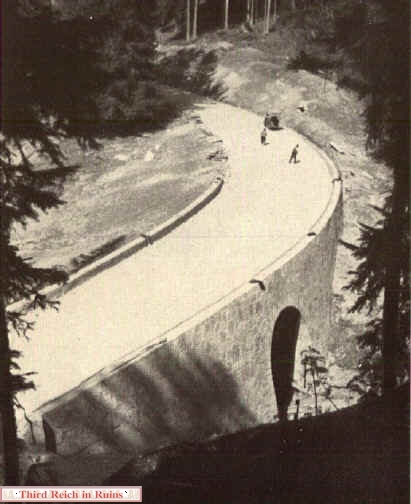
A section of the Alpenstraße under construction,
similar to the section in the photos above.
(Dr.-Ing. Günther Werner-Ehrenfeucht, "75 Jahre Polensky & Zöllner,"
Frankfurt a.M., Brönners Druckerei, 1955)

|

|
These
bridges on the Rossfeld Ringstraße (above) and the Obertalstraße (below)
were also products of the Third Reich period construction in the
Obersalzberg region. |
 |
 |
-
 |
 |
 |
| A
curious structure that can be seen in various period photos on top of
the Bodnerbichl hill, overlooking the Platterhof
hotel, was apparently a large siren for air raid warning. This structure
can be seen at the top of the hill on the right side of the top photo of
the Platterhof complex (see close-ups below). In the 1945 photo below of
the damaged Platterhof, the siren structure can be seen on the hill
above the hotel, near a Moll-System
guard bunker. (above - photos by Ernst Baumann (author's
collection); below - U.S. Army photo, National Archives) |
 |
 |
 |
 |
| These
concrete remains on top of the Bodnerbichl appear to be remains of the
base of the siren structure. At any rate, they are in the correct
location. (I have not seen this siren or these remains identified in any
other publication.) |
-
 |
 |
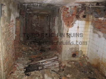
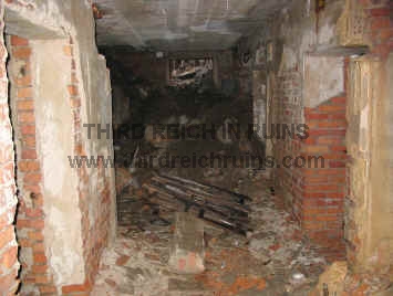
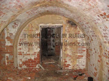
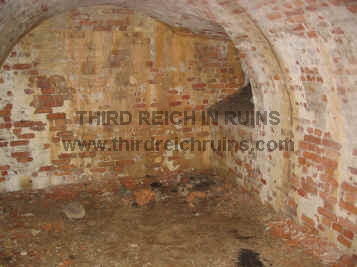
| Although
it is sometimes described as a bunker today, this ruin is thought to be the cellar of a bee house built by Martin Bormann in the
Landlerwald area of the Kehlstein foothills, near the Kehlstein road.
(Another bee house was built in the Gutshof meadows - click here
for photos.) In his book History of the Eagle's Nest
(1998), historian Florian Beierl describes it as the possible location
of the mysterious "N2" site - reportedly an SS communications
site used at the end of the war to send secret radio messages.
Certainly, the construction style and masonry do not indicate a bunker,
and this may simply be an old cellar of a forgotten Obersalzberg
mountain hut (although it would certainly have been an elaborate
example). The entrance (seen below) is nearly hidden today, and the
bricked interior is in a state of decay. The water spigot in the final
photo below has worked in the very recent past (but as of 2012, the
valve was missing). |
 |
 |
 |
 |

This is the bee house built under Martin
Bormann's orders in the Landlerwald woods. The "N2" object may have
been the cellar of this bee house.
(Compare to the other bee house in
the Gutshof meadow.)
-
 |
 |
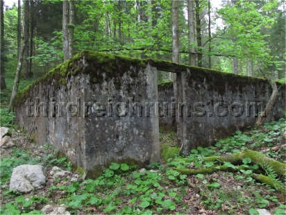
| The
Obersalzberg was supplied by an elaborate water system, including
several underground water reservoirs. This large concrete reservoir ruin
can be found above the Hintereck and Klaushöhe areas, near the
Kehlstein road. The photos to the left above and below show damage to
the roof that was apparently a result of the bombing attack on 25
April 1945. Surprisingly, this reservoir remains dry today. (My
thanks to my friend Ralf Hornberger for showing me this ruin and the one
above.) |
 |
 |
 |
 |
 |
 |
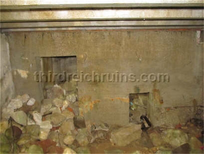
| Remnants
of the waterworks system can be found in many locations on the
Obersalzberg. This access point is near the Carl-von-Linde-Weg walking
trail. The small metal plate sticking out of the concrete just to the
side of the access cover was for workers to clean their boots before
entering the shaft, so they would not introduce mud into the water
system. The mountain water still flows freely through here, and much of
the rest of the 1930s water system. |
 |
 |
 |
| The
waterworks projects also included routing streams and run-offs through
artificial channels lined with stone or even concrete, to control
erosion. There are many examples of this type of work in the
Obersalzberg region; these can be seen along the Obertalstraße. They
still work very efficiently today. |
For further information, including Internet links, check
the Bibliography page.
 Continue to other Obersalzberg sites - Hitler's
Berghof, Bormann's and Göring's houses, Platterhof, Gästehaus and Kampfhäusl,
Hotel zum Türken,
Gutshof and Teehaus,
Kehlsteinhaus, SS barracks, bunker system,
SS guard houses, other miscellaneous area
buildings.
Continue to other Obersalzberg sites - Hitler's
Berghof, Bormann's and Göring's houses, Platterhof, Gästehaus and Kampfhäusl,
Hotel zum Türken,
Gutshof and Teehaus,
Kehlsteinhaus, SS barracks, bunker system,
SS guard houses, other miscellaneous area
buildings.
Visit
Berchtesgaden / Obersalzberg area anti-aircraft (Flak) positions
Click here to visit
a page about the capture of German Gen. Tolsdorf by the 101st Airborne Div.,
near Hirschbichl, Austria.
 Return to the Third Reich in Ruins homepage
 |
My guide
book to Third Reich sites in the Berchtesgaden and Obersalzberg area has
been published by Fonthill Media.
"Hitler's
Berchtesgaden" is available at Amazon and other retailers (the
Kindle version is also available from Amazon). |
Guided Tours
For personal guided tours in
English of Third Reich sites in Berchtesgaden and on the Obersalzberg (and other
local sites) from a certified and accredited local tour guide, contact:
Tom Lewis
+49-(0)1602-641-800
atobersalzberg@sky.com

BEGAFILM
- Historic Films About Berechtesgaden and the Obersalzberg
|