Schweinfurt, Part 2
Bombing Damage to the City
In April 1945, after more than 20
bombing attacks in 18 months, much of the city of Schweinfurt was left in ruins. Although
only the ball bearing factories had actually been targeted, collateral damage to the city
center and surrounding areas was severe. Over half of the houses in Schweinfurt were left
uninhabitable. During the war, the city's population dropped by 50 percent due to
departing refugees.

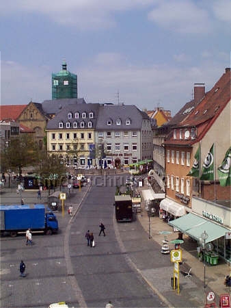
The Marktplatz (city square) as seen from the tower of the
Rathaus (city hall).
A postcard view from 1943, before the first bombings. (author's collection)
-
 |
 |
| Workers
repair damages in the Marktplatz following the first bombing attack on
17 August 1943. The Rathaus is to the right. The building in the center
distance (on the street corner) is the birth house of Schweinfurt's most
famous native, the poet Friedrich Rückert. (Stadtarchiv Schweinfurt) |
 |
 |
| The east side of the Marktplatz
as seen from the Rathaus tower, sometime in 1944. Note how the roofing
tiles have been blown off the roofs - the preferred bombing technique
for residential buildings was to first drop high-explosive bombs to blow
off the roofing, then drop incendiary bombs to set fire to the exposed
wooden structures. Compare this view of the ruins to the pre-war
Marktplatz views in Part 7.
(Stadtarchiv Schweinfurt) |
 |
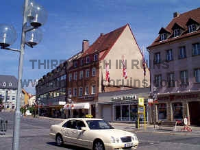 |
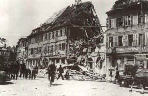
East side of the
Marktplatz, in ruins and in a modern view. This bombed building was only rebuilt to its
original height in 2005 (the rebuilt structure shows in the first modern
photo of the Marktplatz at the top of the page). (Stadtarchiv Schweinfurt) |
 |
 |
| Looking down
Spitalstraße after an attack, with buildings on the Marktplatz on fire. The tower of the
Heilig-Geist-Kirche (Church of the Holy Spirit) appears in the distance in
this view taken from the
Rathaus tower. (Stadtarchiv Schweinfurt) |
 |
 |
| Kesslergasse, a quaint street in
the old town area, leading off the Marktplatz, was left in ruins. (Stadtarchiv Schweinfurt) |
 |
 |
| Much of
Rückertstraße, leading east off the Marktplatz, was destroyed. (Städtische
Sammlungen Schweinfurt) |
 |
 |
| Ruined houses on Fischerrain, near
the Main River. Most were rebuilt to approximate
their original appearance, but the street was widened on the left side.
(Städtische Sammlungen Schweinfurt) |
 |
 |
Wolfgasse, looking
toward the Roßmarkt. Many of the streets were blocked by rubble to all but pedestrian
traffic. (Stadtarchiv Schweinfurt) |
 |
 |
The area around the Zeughaus (old
arsenal, built 1591) was largely destroyed. Only the Zeughaus itself remains
relatively unchanged today. (The tower seen on the left side in the period photo was
not part of the Zeughaus but was actually
attached to a building behind the Zeughaus, no longer standing.) This photo
was taken on the same spot as that just above, by the photographer
turning 90 degrees to his left. (Städtische Sammlungen Schweinfurt) |
 |
 |
| Damage
along Neutorstraße was so severe that the post-war rebuilding in this
area left only the small kiosk at the right edge of the photo recognizable
today. (Stadtarchiv Schweinfurt) |
 |
 |
| Closer
to the ball bearing factory areas, houses along both sides of
Luitpoldstraße burn after a bombing attack. (Stadtarchiv Schweinfurt) |
 |
 |
Buildings
along Cramerstraße, across from the VKF-1 factory,
were substantially destroyed during the war. (Stadtarchiv Schweinfurt) |
 |
 |
| The area around the main train
station suffered heavily due to its proximity to the factories. This view looks down
Hauptbahnhofstraße toward the station, which burns in the distance. Only the small building just left
of center in the period photo remains. The larger house was later destroyed, and not
rebuilt. The postwar headquarters building of FAG-Kugelfischer appears in the right
distance. (Stadtarchiv
Schweinfurt) |
 |
 |
| Most of
the wartime rubble clearing was done by women, the so-called Trümmerfrauen
(rubble women - the photo on the left above does not show Schweinfurt,
but is representative). After the war, a series of narrow-gauge railways
was built in the city to facilitate the removal of the rubble to a
collection point on clear ground near the Kugelfischer factory ruins. This
rubble was piled into a hill that is now a city park, the Schuttberg.
The monument seen below, on the Schuttberg, commemorates the
rebuilding of the city. Occasionally, fragments of the bombs themselves
can be found in the area, like the one on the right below. (above
left - Imperial War Museum, London; above right - Stadtarchiv
Schweinfurt; below right - author's collection) |
 |
 |
 |
 |
| Not only
Schweinfurt itself suffered damage, but several surrounding villages did
as well. The town of Oberndorf suffered particularly due to its
unfortunate position relative to the bearing factory area. As the lead
bomber, coming in from the southwest, released its bombs over the
target, the following bombers released their own, causing many to fall
just short of the factory area into Oberndorf itself. These photos show
an old farm building that shows reconstruction after wartime damage.
This is in the town of Ettleben, southwest of Schweinfurt. Ettleben did
not suffer from bombing attacks on Schweinfurt, but from direct fire,
artillery, and fighter-bomber attacks during the second week of April
1945, as the U.S. Army advanced on Schweinfurt. Ettleben was the
location of a large Flak Battery that stood in the line of advance, and
fired on the U.S. forces until it ran out of ammunition. During the
three-day battle, much of the town of Ettleben itself was destroyed. |
Memorials to the
Bombing Victims
-
 |
 |
| Local
Nazi officials conduct a memorial ceremony in the city cemetery (Friedhof)
in 1944, in one of the sections reserved for victims of the bombing
attacks. The large banner displays the German runic symbol for death.
This part of the Friedhof, between Sections 32 and 36, still
holds the graves of bombing victims, 1943-45. Other bombing victims were
buried in Sections 9 and 17. (Stadtarchiv Schweinfurt) |
 |
 |
| The
grave markers often tell a graphic tale of multiple family members
killed in the same attack. The Bardolf family lost three members on 14
October 1943, while a young woman and two young children of the Bickel
family were all killed on 31 October 1944. |

Monument in the Schweinfurt city
cemetery, over a mass grave containing the bodies of 142 citizens who died in
the bombing attacks from 1943-1945.
"Black Thursday" was the day of highest casualties for the Allies, but
the most costly attack to Schweinfurt civilians was the combined 8th Air Force
and RAF attacks
on 24-25 February 1944, during which some 700 aircraft dropped some 3500 high
explosive bombs and 33,000 incendiary bombs, killing 362 civilians - a third of
the total
for the war (1079). Many of these victims were French and Russian prisoners of
war, forced to work in the ball bearing factories to take the places of German
men who were serving at the front.
I wish to acknowledge the kind
assistance of the staff of the Stadtarchiv Schweinfurt provided during my photo
research there; and to express my thanks to Oberbürgermeisterin (Mayor) Gudrun
Grieser for permission to photograph from inside the Rathaus tower.
 Continue to Schweinfurt, Part 3 --
Flak (anti-aircraft) defenses of the city
Continue to Schweinfurt, Part 3 --
Flak (anti-aircraft) defenses of the city
 Back to the Third Reich in Ruins homepage Back to the Third Reich in Ruins homepage
Click
here for a link to a MapQuest map of Schweinfurt.
|

